Home { Archipelago Commons 1.5.0 Live }
People Got to Be Free

Main navigation

  • Browse Digital Objects
  • Extracted Text Discovery
    • Search inside Web Archives
    • Search inside Book/Document Pages
  • Learn More
    • About
    • Community
    • Documentation
    • In the Wild
    • Advisory Board

Tools

  • Tools

Discover

User account menu

  • Log in
Displaying results 1 - 4 of 4
List Display

Historical Maps of New York City and Surrounding Areas

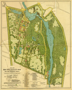
Final plan for the development of the New York Zoological Park as presented by the New York Zoological Society, in 1897

Thumbnail for

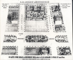
Old auction lot map of 36th and 37th Streets between Madison and Park Avenues

Thumbnail for

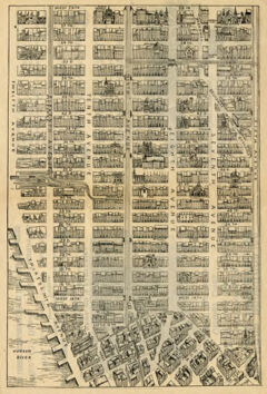
Map of Midtown Manhattan down to Greenwich Village

Thumbnail for
More Options
  • Map (3)
  • Collection (1)
  • image/jp2 (2)
  • image/jpeg (1)
  • Archipelago Demo Collection (3)
  • E.H. Ludlow & Co. (1)
  • New York Zoological Society (1)
  • Show all (14)
  • (-) Maps (4)
  • Bronx (New York, N.Y.) (1)
  • Bronx Zoo (1)
  • City and town life--New York (State)--New York (1)
  • Greenwich Village (New York, N.Y.) (1)
  • Madison Avenue (New York, N.Y.) (1)
  • Midtown Manhattan (New York, N.Y.) (1)
  • Murray Hill (New York, N.Y.) (1)
  • New York (N.Y.) (1)
  • Park Avenue (New York, N.Y.) (1)
  • The Bronx (1)
Back to top